
The popular Devil's Garden trail was about 20 miles from the Arches National Park entrance and usually very crowded. We decided to hit it early and beat the crowds. Our plan was to complete the easy 0.8 miles to Landscape Arch and then evaluate our resolve to continue on to Double-O Arch (an additional 1.2 miles). The trail immediately took us between some rock fins and then opened up to some expansive views.

The Devils Garden trail ranged from easy to challenging, depending on how far you wanted to hike.


The trail was exceptionally smooth hard packed ground (it might have been paved under a layer of sand and dust) for the first 0.7 miles and then it changed to deep loose sand. Sand might be my least favorite type of trail. It seems like you make twice the effort for half the progress, but it was level, and really, there was no hurry. When Landscape Arch came into view we were stopping every few feet for pictures anyway.
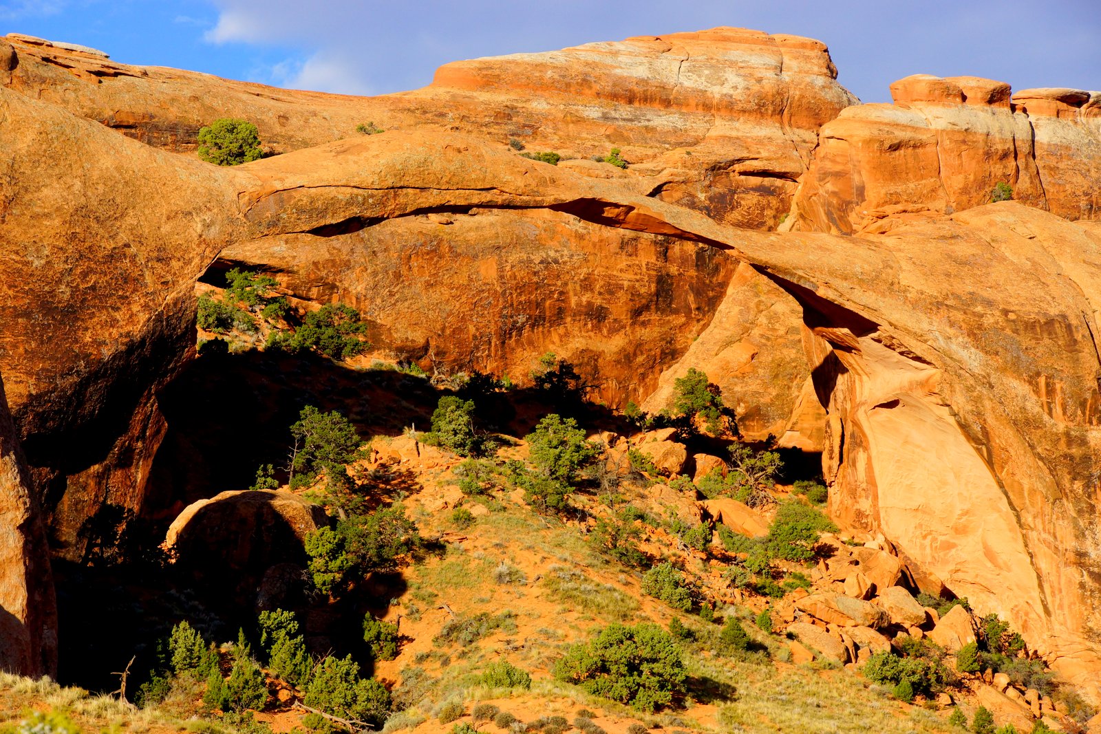
Landscape arch spans 290 feet and the thinnest section is only 6 feet thick.


It's unbelievable that someone captured the rockfall on video. I wish I could see that!

We decided to continue on to Double-O Arch. A sign told us the trail was going to be primitive, but I did not realize how poorly it would be marked or just what challenges the primitive trail would provide. Since we were early, there was no one to follow. I thought I could see a slight difference in the rock where hikers had passed which was the only indication I had for direction. The trail went straight up a rock fin. There were no signs or cairns, it just went up very steeply and out of sight over the top. I went first and finally reached a sign that let us know we were on the right track. I called down to Joani and she reluctantly followed me up. The other couple in the picture below decided if Joani could do it, they would try it also.


Another sign pointed us onto another fin. There were no cairns, but then, there really were no options other than to follow the fin to its end.

It gave you one of those "I'm on the top of the world" feelings, as beautiful panoramas opened up in every direction. Some sand covered rock at the end of the fin took me by surprise and I got a nice bruise on my hip as a souvenir. That was a good reminder to pay attention, even when I'm back on flat ground.

View from Black Arch Overlook (it's just above center in the picture and pretty hard to see.)

I had not seen any pictures prior to our hike and had wondered about the name "Double-O Arch," but it was immediately clear when we saw it. One other couple was just leaving, so we had the arch to ourselves for a while.

Just a little scrambling over the rock and through the bottom arch put us on the other side of the arches. The upper arch nicely framed the distant landscape. Joani noticed a hollow sound as we stepped on the rock leading me to believe the lower arch will open into a larger arch soon (maybe in the next few thousand years).

We took a break for some water and a snack and I wondered if I was seeing the last feature on the trail named Dark Angel, a large black rock monolith. I checked with a hiker who had just returned from that direction. She said that was indeed it (and she was not impressed.) Since we were still more than two miles from the car, we chose to head back without the extra mile out to Dark Angel.
On our return, there were a couple of side trips that were mandatory. The first was named Navajo Arch (.3 mile spur) and it was beautiful. As we walked all around this arch taking pictures from every possible angle, it occurred to me that there were no rocks on the ground. Where were the rocks that fell away from the fin above to create the arch? I have my own theory. Before there was an arch, the rain backed up behind this fin which acted as a natural dam. This spot was a little more porous which allowed water to seep through weakening it until the pressure pushed through creating a drain hole. The water in the lake then rushed through clearing out any remaining loose rock.
Maybe I should present my theory of arch formation. Maybe it would revolutionize geological thinking in the park. Maybe I would receive a Nobel Prize. Maybe it's too early in the morning for blogging!


It looks like we are in a cave looking out, but no,...

...there is another fin at our back and sky above.
Our next side trip (.2 mile spur) took us to Partition Arch. This was visible from the overlook at Landscape Arch, but it had a completely different feel from this perspective.

Some fluffy clouds popped up to provide some nice sky to frame in this arch.


It was late enough that the trail was now crawling with hikers - we had no problem retracing our steps back along the fins and out of the wild backcountry.


Joani's shoes stay cooler because they are ventilated, but the downside, when hiking a sandy trail, is apparent. There was probably a quarter cup of sand along for the ride as she hiked. After more than five miles of hiking, it was time to head home and relax for the rest of the day!


No comments:
Post a Comment