We decided we would go ahead with our original (shortest) route from our campground in Bowie, AZ, to Chiricahua National Monument in Hilltop, AZ, even though it meant driving on 8 miles of unpaved roadway. I took it slowly and we enjoyed the solitude. There were no issues with the road - it was pretty narrow in places and we crossed a little bit of running water (fortunately it had not recently rained) but we made it back to the security of paved roadway.
Google maps made it appear we would have options along this dirt road (Apache Pass Rd), but not so. Just follow the road and it will take you to Hwy 186.
I kept expecting to see something in the distance different from everything else around us that would distinguish its National Park Service attention.
When we arrived at the monument entrance it was still not apparent just what made this place special.
Finally, the view opened up and I saw the beginnings of some very different rock formations. Chiricahua National Monument preserves the remains of an immense volcanic eruption that shook the region about 25 million years ago. The thick, white-hot ash spewed forth from the nearby Turkey Creek Caldera, cooled and hardened into rhyolitic tuff, laying down highly siliceous, dark volcanic ash and pumice almost 2,000 ft deep.
The further we drove into the park the more dramatic the landscape became. Below was a bit of the Organ Pipes formation. The Chiricahua Apache called this the Land of Standing Up Rocks and the spires certainly lived up to the name.
The main road, Bonita Canyon Drive, leads to a "sky island" that you can view from Massai Point at an altitude of 6,870 feet.
Just to the right of center in the view below you can see a very thin spire I believe was named Totem Pole rock. It is enlarged in the next picture below.
The slender spire is the Totem Pole. It is 137 feet tall and is but 3 feet in diameter at one point near its base.
We hiked a very small part of the Echo Canyon Trail finding so many unique and seemingly impossible rock formations along the way.
The Arizona Cypress along the Massai Nature Trail had a wonderful aroma.
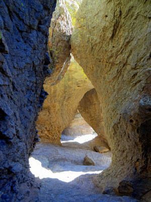
About a quarter-mile along the trail we reached the Echo Canyon Grotto. We were able to climb in and around the rocks sometimes finding ourselves under some very large boulders wedged in between the columns.
The rock below was named the Sea Captain. I think it was pretty aptly named.
First, you see his eye and then the captain's hat.
We opted for pavement all the way home via Hwy 186 taking us to Wilcox, AZ, where we had a great meal at Isabel's South of the Border and chanced upon a small street festival. Sam was waiting for us at home so we didn't spend much time there. One day we will return and visit the Rex Allen Museum and spend a little more time exploring the town.


No comments:
Post a Comment