Wednesday, May 30, 2018, Pierce Stocking Drive


From our campsite at Sleeping Bear Dunes North Platte River campground, we headed north along the lakeshore with our first stop at Esch Beach. Reviews told us it would be a good place to find the elusive Petoskey stones. Another review said it was no longer a nude beach, but as cool as it was I didn't think anyone would bare it all today. As you can see below, Joani found one! It was very distinctive - there was no mistaking it was fossilized coral and it was the right size for our souvenir rock collection.


Our next stop was actually a driving tour called Pierce Stocking Drive. It was a 14-mile loop drive through some very tranquil woods punctuated with dramatic views of the dunes and Lake Michigan.

It is easy to see how this came to be named Alligator Hill.

One stop along the drive was at the top of a dune. Signs warned that it was very steep with a 450-foot elevation drop to the water's edge. Two school buses unloaded kids with no concept of just how tough that climb would be, so after the easy slide down a few kids and a few adults were struggling to make it back up. They needed a lot of help and had not made it back up before we left. I can only imagine how embarrassing it will be. Good thing it is almost the end of the school year so the teasing won't last long.


When we completed the Pierce Stocking drive we decided to check out a few sights south of our campground on our last day before moving on. We visited a highly regarded beach in Elberta that really did nothing for us, but we did walk out a long, long pier to marker lights at the entrance to the Frankfort Harbor (which is where the Betsie river joins Lake Michigan). Below is the Frankfort North Pier Head - I don't know how it differs from a lighthouse, but I trust Google maps has it correctly identified.


On the way home, we stopped at Point Betsie Lighthouse. It was closed for the day, but we had no problem walking around the grounds to find a good shot of this very nice looking structure. Nearby we joined several other people looking for rocks along the shoreline. One local guy found a Petoskey stone that he showed me. When I told him I had not yet found one yet he gave it to me since he had a sizable collection already. I accepted it since it was my birthday although I never mentioned that to him.

Tuesday, May 29, 2018, Sleeping Bear Dune Climb


Sleeping Bear Dunes National Lakeshore stretches for about 35 miles along Lake Michigan. They have a nice visitor center, located in Empire where I was able to get my first National Park passport stamp in the mid-west region.

While we were waiting for the park documentary movie to begin, we were amazed by the four-panel quilt hanging in the theater. Joani gives the work some scale. If I hit the lottery, I would have to have this!

Sleeping Bear Dunes, 2013
Ann Loveless
textile applique

 What a masterpiece! (Close-up on panel four)

 (another close-up on panel four)

We returned to the Sleeping Bear Point Coast Guard Station west of Glen Arbor. This time we let Sam stay at home so we didn't have to leave him in the car (no dogs allowed) while we visited the buildings and exhibits. In the boathouse, we saw some of the boats used to save lives from the more than 100 shipwrecks in the area. What I liked best about the boathouse was its construction. The entire post and beam frame was pegged - no nails were used. I also loved the detail in the roof with the flared roof and the round cupola.


The Breeches Buoy (upper left corner of the picture below) helped get sailors to shore when their ship ran aground. Sailors would climb into the breeches buoy like a pair of pants before being pulled ashore.


The Manby mortar fired a projectile that carried a small rope to a wrecked vessel. Then the Breeches Buoy would be sent back and forth carrying survivors. In one case, a Manby mortar helped save 291 lives from Ayrshire in January 1850.


The faking box below was used to arrange the rope so that it would not tangle as it was pulled out by a projectile fired from a cannon.

The Faking Box had wooden pins used to fake (coil) the line. Before attaching the line to the Lyle Gun Bullet, rescuers would invert the pin board and allow the line to drop into the lid of the box. Then the line was ready to play out smoothly when the shot was fired. The shot line was then tied to the heavier Hawser line for rigging the Breeches Buoy.


The main house provided quarters for the Coast Guard crew. It reminded me of a fire station with beds and a small closet for each man. They were always ready to jump into action whenever a ship was in trouble.


About a mile away in the blacksmith shop volunteers demonstrated iron working skills from the 1800's. We made a hasty retreat as two school buses pulled to the curb disgorging lots of loud students happy to be out of class for the day. 


We finished our day's explorations with the "Dune Climb." It seemed like a good idea to climb until we were tired then it would be an easy downhill trip back to the car. What I had not considered was the temperature, a sunny 91 degrees, made the sand nearly unbearably hot. There was no way I was going to climb barefoot and flip-flops were only a little better.

Like other dunes we have climbed, we never seemed to reach the highest point. Each time we crested a hill there was another even higher dune in front of us. Sometimes you had to go down one dune to get to the next one, so getting back to the car was not as much downhill as I would have liked.

This is the view of the "Dune Climb" from the road.  The climbers look like little specks.

It was 91 degrees and that sand was hot! Be sure to wear shoes!!!

Looking back from whence we came you can see Glen Lake.

We were told it was nearly 3 miles before you reach the shore (and then 3 miles back!) Once Lake Michigan came into view, we decided that was enough.

You can see in the panorama below we were further up than most people. It was very quiet and secluded. It might have been a good day to bring a few beach towels and get a little sun.

Monday, May 28, 2018, Traverse City Asylum


We moved to Sleeping Bear Dunes-Platte River Campground in the Sleeping Bear Dunes National Lakeshore - a drive of 45.8 miles (87,102.9 total). Along the way, we nearly hit a deer that bounded across the road right in front of the motorhome. Joani saw it standing on the edge of the road and thought it was a yard ornament until it moved. Fortunately, we were probably doing no more than 10 mph (since we had just stopped at an intersection) and I was able to hit the breaks. I would guess he cleared us by less than 8 feet.


Our campground was part of the National Park System so our America the Beautiful pass secured us a nice 50 amp site at a very reasonable $18/night. The sites were widely spaced and we were a short walk away from a nearly new bathhouse - what more could one ask for?

With the whole afternoon in front of us, we decided to visit the Traverse City State Hospital, also known as the Northern Michigan Asylum. At least it was an asylum when it opened in 1885. In the 50's it was abandoned and fell into disrepair. Starting around 2000 plans for refurbishment were put in place and by 2014 most of the main building had been repurposed as shops and private residences. The beautiful Italianate style building contains nearly 400,000 sq ft. There is no place on the grounds where one can see the entire building and I lost count of how many towers decorated the roof (although aerial pictures seem to show 14).


A gracious shop owner, returning from a run, opened her shop when she saw us peeking in the window.

Colantha was born 4/29/1916.

We didn't spend a lot of time at the Asylum since most everything was closed (it was Memorial Day) and decided to revisit Front Street in Traverse City.


Of course, I had to see if the chocolate covered cherries at the Cherry Republic were still good - they were! We headed home after yet another beautiful, relaxing day in the great state of Michigan.

Saturday, May 26, 2018, Leelanau County, MI


From our base at Leelanau Sands Casino, we set out to explore more of the peninsula and the small Michigan towns scattered along the shoreline. Our route was a loop mostly along Michigan's M 22. It was clear cherry trees and vineyards were area favorites.

Joani Googled best places to hunt for Petoskey stones which resulted in our trip out to Lane Road Beach in Port Oneida. A short graveled road and a long stairway took us to a very secluded shoreline. We saw one guy packing his kayak for a camping trip out to South Manitou Island. I don't know how many trips he made up and down those stairs, but I'm sure he got a pretty good workout before he even started paddling.

There was one family fleeing from the onslaught of midges who said they had no luck stone hunting. We probably only spent a few minutes searching before we decided to leave as well, but it seemed like a lot longer with the flying pests hounding us with every step. We left empty handed but determined to continue our rock hunt later.


Glen Arbor, another nice little tourist town, was next along our M 22 tour.  The original Cherry Republic was located in Glen Arbor. Sure, I already sampled everything they have in Traverse City, but I had to make sure it was all good here too - right? Joani went in first and brought me a sample of cherry pie and some chocolate covered cherries, yum!

I also purchased a t-shirt to help assuage the oversampling guilt.


From Glen Arbor, we followed M 109 out to Sleeping Bear Point. The National Park Volunteers were out in force with demonstrations at the Life Saving Station and the blacksmith shop, but Sam was not allowed, so we decided to return another day to thoroughly explore everything.

In another small berg named Empire, we made our way to the shore again. This was a happening place, comparatively speaking, with lots of folks along the beach. In the picture below you can see the Robert H. Manning Memorial Lighthouse. It seemed like a good target for a beach walk.


As we neared the lighthouse we realized it wasn't quite what we were used to. I suspect inside the door there's nothing but a spiral staircase


We were ready to call it a day, so we took M 72 back to Traverse City, picked up a few supplies and then returned to the casino for the evening. We love that there was so much to explore in such close proximity. If it were not for the 6 months of the year with arctic conditions this might be a great place to settle.

Friday, May 25, 2018, Leelanau Sands Casino, Sutton's Bay, Grand Traverse Lighthouse


One of these days I will have to drive a long way and I will not remember how - today was just 24.0 miles (87,057.1 total) to the Leelanau Sands Casino in Peshawbestown, MI. That might be one of the most bizarre town names of the places we have stayed to date. During much of our drive along Michigan highway 22, or M 22, we could look over and see Lake Michigan. That made the short drive even more pleasant. Leelanau Sands offered parking with 50 amp power and a view of the lake for $10/night - quite reasonable compared to most options in the area.


RV area is at the north end of the parking lot across the street from the casino. You must sign up for a players card and pay in the gift shop (two-week limit).

We found ourselves with most of the day ahead of us after we settled in at the casino, so we took a drive to Sutton's Bay a few miles south of our campsite.


I was told about a telescope shop that I would find interesting and I was anxious to visit. The owner taught astronomy for 30 years at a nearby college. On the side, he opened a store he named Enerdyne where he sells anything he finds interesting or related to science. He certainly had a lot of fun "toys" that I would love to have if I only had the space in our little home on wheels.


We walked along North St. Joseph Street (the main street through Suttons Bay) for a while and looked in a few shops and galleries. We are not very tempted by art or designer clothes or nicknacks, so we escaped with nary a purchase.


Later, we still were not ready to settle in for the evening, so we ventured out again to the north this time toward Grand Traverse Lighthouse.

The lighthouse was erected 1858. In 1900 it was converted to a two family dwelling - I assumed for the lighthouse keepers. What was interesting to me was that they didn't add a kitchen until 1916 and they didn't have electricity until 1952.


We continued around the upper part of the peninsula with our next stop in the Leland Historic District (also known as Fishtown). The fishing district was established over a hundred years ago. Some of the older buildings date back to the lumbering and smelting operations in the latter half of the nineteenth century. Today residents of Leland make a living from fishing and tourism including ferry service to the Manitou islands.


The windsurfer looked like he was having a great time zipping across the water even if he needed a wetsuit to survive in the frigid lake. He was also a good indication that there was a stiff breeze coming off of the water that made sweatshirts a good choice for us as well for the afternoon.

Thursday, May 24, 2018, Traverse City, MI


Just north on Michigan highway M 31 in the small town of Elk Rapids we sauntered through a sculpture park filled with modern art dubbed the "Walk of Art."

Blue Sculpture with yellow ring, 2010
by David Petrakovitz

The "bird" below was fabricated out of all sorts of scrap parts. I noticed a Volkswagen hood stretched from the head to the legs to form the creatures breast and belly. Sam didn't know what to think about the piece.

Amelia, 2017
by Ritch Branstorm

Everywhere in the woods around us the Trillium was in bloom - that was a different kind of art all together.


Hardwoods, 2016
by Sam Soet

Joani and I both agreed the work below was our favorite. She was embracing the sun and sky while facing the waters of Lake Michigan.

Becca Triumphs, 2013
by Ann Gildner

If I had a garden and a spare $15,000 lying around, Becca would be mine!

Joani spotted this uncredited work of art entitled Spalding mounted carefully in the crotch of a tree.


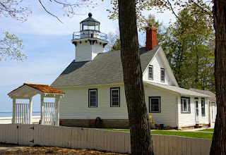
We returned to the coach for some lunch, but quickly headed back out on the road. North again, but this time up the Old Mission Peninsula on M 37 until we reached the end of the road where we found the Old Mission Lighthouse. The lighthouse was closed for the day, but we were happy to just roam the grounds and take pictures of the structure - I think we already know pretty much what we would see inside.


The bugs were even worse than at the campground, but we learned from a local that these were called "midge flies" or just midges. What we thought were mosquitoes when we arrived yesterday were midges - so that's why they didn't bite. Still, they were pests flying in your face and ears. Sam swallowed a couple sending him into a coughing fit.


I was relieved to find out the clouds of swarming insects were midges instead of mosquitoes.


I'll take the non-biting midges over mosquitoes any day!

Back in town, I found I was the first to arrive at the movie premiere, well, if you don't count R2-D2 and his Imperial companion. What a nice theater - nicely restored with maybe 400 seats and a balcony! I can't remember the last time I saw a balcony in a movie theater, but my favorite detail was the starry ceiling.


I guess there were maybe 200 people in the theater for the movie, so there were plenty of empty seats. Believe it or not, I didn't hear a single cell phone ring during the entire movie!