Friday, July 12, 2024, Move to Hopewell Cape, New Brunswick, Canada

We were scheduled to have pancakes and sausage served up by our tour hosts but four inches of rain overnight inundated the gathering room and breakfast had to be cancelled. The water was so high we had to find an alternate exit to avoid the foot deep water over the normal exit drive.


The Debert River was nearly over the levee.

Our travel today took us 118 miles to Ponderosa Pines campground on Hopewell Cape, New Brunswick. This park gave us easy access to Hopewell Rocks Provincial Park. We backed into a new site that was level, high, and dry!


The park could not accommodate our entire group in one area but we had a nice gathering area near our Wagon Masters coach at the end of the park (just beyond the truck on the right).


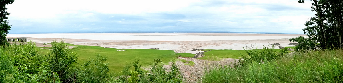
A few steps away from our site was a trail to a Salt Marsh along the Bay of Fundy.


We could have hiked many more miles through the forest but it felt like we needed to drive to the provincial park to see one of the iconic scenes of this tour. I took a few pretty pictures and we returned home.


We relaxed a bit waiting for high tide before heading to Hopewell Rocks (also known as "Flowerpot Rocks"). I had no idea how far it was from the parking lot to the overlook. It was more than I would have elected to hike but we had to see the rocks at high tide and this was our only opportunity. We made it to the overlook just a few minutes after high tide but I doubt we would have noticed a difference. It was a long uphill climb back to the car and there was an option to ride a cart to the top but we were good and got our steps in.


While it was still daylight and nearly high tide we checked the salt marsh again and could see a significant difference in the water level.


Happy to be out of the rain for a while and with so many steps for the day we settled in for a good night's sleep. 

Thursday, July 11, 2024, Tidal Bore at Burntcoat Head, Nova Scotia, Canada

We planned a trip to the Shubenacadie River to witness another tidal bore on the Bay of Fundy. Since we were early, we drove a bit further to Burntcoat Head Park on Cobequid Bay. This was the site of the world's highest tide at 53.6 feet. Unfortunately, the moon's orbit placed it in a position to only create about a 29-foot tide during our visit.

There was a mass of humanity walking the sea floor and playing in the thick mud. Lucky for them there was a foot washing station to clean up before returning to their cars. Unfortunately for them, there was a long queue that moved very slowly.

As the tide started back in, we headed to the Fundy Tidal Interpretive Centre near South Maitland, NS. There we walked by a Dominion Atlantic Railway caboose commemorating the Land of Evangeline Route (I'll have to delve into that history another time) on our way out to an observation platform atop old railroad bridge pilings.

It started sprinkling as we waited. We were now accustomed to seeing people we knew from our tour and we had quite a good showing on the platform.  


 Laye, Sam, Marcia and Will


Reggie, Teresa, and Linda trying to stay dry.

A park ranger from the center talked about the area and what we would see.

She showed us a photo she had taken of the highest tide she had seen on the bridge support.

We waited patiently as the rain increased. The tidal bore was about 20 minutes late and we were all pretty wet by the time it finally arrived. It was a bit underwhelming due to the limited visibility and the low tidal range but we did finally see a wave crest and the sand bar was quickly covered.

Another 10 minutes passed before we saw the mud runners racing upriver. They circled below us before beaching on the muddy bank of the Shubenacadie River.

I took one last picture of the bridge support for comparison with the ranger's high water photo. Of course, we were not yet at high tide but there was clearly no comparison with the record tide she had photographed. The rain refused to quit and we had seen enough so we headed home happy to dry off and warm up.

Wednesday, July 10, 2024, Move to Elm River Park, Glenholme, Nova Scotia, Canada

The move from Cove Oceanfront Campground to Elm River Park near Glenholme, New Brunswick, was 180 miles. We never found out why the Elm River Campground was on the banks of the Debert River. We quickly set up camp and headed to the Fundy Discovery Site to see the tidal bore. The view when we arrived included a large sandbar in the middle of the river.


We saw a large contingent of Fantasy Tour members lining the walkway of the viewing area.

Mark, Monica, Marcia, and Butch are to our right.

Sherry and Chris are to our left.

Joan and Annalee, are not far away.

We only had to wait a few minutes before the water rushed through the tidal bore. We first saw a wave of water round the bend and within a few minutes the sandbar was underwater as the level quickly rose. The Salmon River flow was overwhelmed by the Bay of Fundy tide. The tidal bore was earlier than forecast and a busload of disappointed tourists sadly arrived a few minutes too late to see the spectacle. Hopefully, they were staying around long enough for the next high tide.


We stopped at the Masstown Market on the way back to the campground. It was one of the nicest markets we visited in Canada. There was a huge variety of fresh fruits and vegetables and ready to heat-and-eat meals. We picked up a Lobster Pot Pie and a Ham and Cheese Quiche.

Tuesday, July 9, 2024, Port Royal and Digby, Nova Scotia, Canada

From Parker's Bay, we visited the Port Royal National Historic Site one of the earliest European settlements in North America. The original habitation was built by Samuel de Champlain in 1605. His drawings and plans were used for the reconstruction using the same materials and tools. Beautifully crafted timber frame construction was assembled with no nails. Mortise and tenon joints were locked with pegs. 


Interpreters in costume described life's challenges in the fort and their relationship with the native Mi'kmaq.


Only a few of the rooms had windows with glass panes. Most of the windows had oiled sheepskin instead of glass that allowed in some light while keeping out the insects and cold.


Many of the rooms led one into another so the blacksmith was next to the kitchen next to the bakery which led into the common room.


One corner of the habitation was the house for the governor. He had a bit more room and luxury. Upstairs was a four-poster bed. 


Port Royal was only occupied for a short few years before politics across the ocean changed direction and it was abandoned. The land was farmed for hundreds of years before the decision to reconstruct the habitation. We were told there were probably only a few stones in the foundation that were original to the 1605 structure.


Next, we headed to the quaint seaside village of Digby, the scallop capital of the world. One of the locals recommended we stop in the Crow's Nest for the scallops. Joani had the seafood chowder loaded with scallops, fish, shrimp, and clams and I had the pan-fried scallops. Both were certainly tasty!


It was a pleasant day so we opted to sit outdoors and watched the tide rise as we ate.


I thought this deck was different. It was originally the aft section of a large fishing boat.


It was nice to see so many faces from our tour around town it made us feel like we were locals ourselves.

Monday, July 8, 2024, Schnitzel, Fort Anne, Campfire Sunset, Annapolis Royal, Nova Scotia, Canada

We woke up to some thick fog and saw something I'm not sure I've seen before - a fogbow! It was sunlight reflected off of the fog so it was exactly opposite the direction of the rising sun.


It was low tide so we walked to the wharf we saw on moving day to have a look. The three boats in yesterday's picture were out fishing and we were looking 25 feet down to the seabed. To contrast, I tried to take the same pictures at high tide the next day.


Fantasy arranged a lunch at a German restaurant in Annapolis Royal. We had our choice of Schnitzel or Bratwurst. Joani had the brat and I had the schnitzel and we shared. I think the schnitzel was delicious and my favorite. Blueberry crumble was served with ice cream for dessert.


Our host, the pastry chef, was from East Germany (her husband was the cook and her daughter was one of the servers). She talked for a few minutes about her history and how they ended up in Canada. She was passionate about what she sees happening to Canada now and the parallels with what she lived through in East Germany. She did not get the memo about no political discussions.


After we finished, Steve, the tour wagon master, tried to round everyone up for a group photo. Talk about herding cats. 


He did get everyone still for a few moments, but we have yet to see the picture so I have no idea if he was successful. I cannot imagine everyone was visible in the picture but maybe he will share it later.

The fog was long gone and the sun was brightly shining. It was a beautiful day for another walk around Annapolis Royal. We started with Fort Anne.


The museum, housed in the last remaining building in the fort, had a model to help visualize the entire fort in its prime.


In a cutaway of the building's wall, we could see how bricks had been used to fill in around the timber framing. Using building materials from older buildings was referred to as "bricknogging".


There was a picture of Queen Elizabeth sewing a few stitches in the tapestry of her great-grandmother, Queen Anne.


Later in the evening we sat around a fire and watched the sunset. Clouds rolled in before it sank below the horizon but we did get to see some nice color even if we didn't see the actual sunset.


The fog rolled rolled in and then it rolled back out again.


Jean, Brian, Jean, Randy and Joani

Jean and Randy's fur baby, Sheldon.

As night fell, we watched a fishing boat work the shoreline.


It gets dark pretty late at these latitudes in the summer so it was time to call it a night after a long and eventful day.