Our last full day in Zion National Park, UT, and it was our last chance to tackle the East Rim Trail to Observation Point. This was the most strenuous of the trails at 8 miles and over 2,200 feet of elevation gain, but it was time. It was also the first day for buses - cars were no longer allowed in the canyon. The Visitor Center was on the way to the tram stop, so Joani enjoyed some of the artwork while I checked weather and trail conditions. The forecast called for a chance of rain starting around 4:00 pm. It was only 10:00 - plenty of time!
Artist Buffalo Kaplinski, the 2012 Zion National Park
Foundation Award winner
Just before the tram got to our stop, it started sleeting for a few minutes - not a good sign. There was a biting cold wind to make the morning even more enjoyable. Undaunted, we headed up the steep trail. It quickly climbed high above the canyon floor as the sleet returned. I should note that the sleet was not like any other I have encountered. It would hit the rock and bounce and roll, but it was soft, like tiny snowballs, and there was no rain mixed in with it at all. It bounced off of us without getting us wet (I had ponchos, just in case). Fortunately, Joani had included a scarf and earmuffs for me that just might have saved my life.
I insisted - no hiking in the rain! I never considered snow!
I would describe it as snow pellets, soft eighth-inch snowballs.
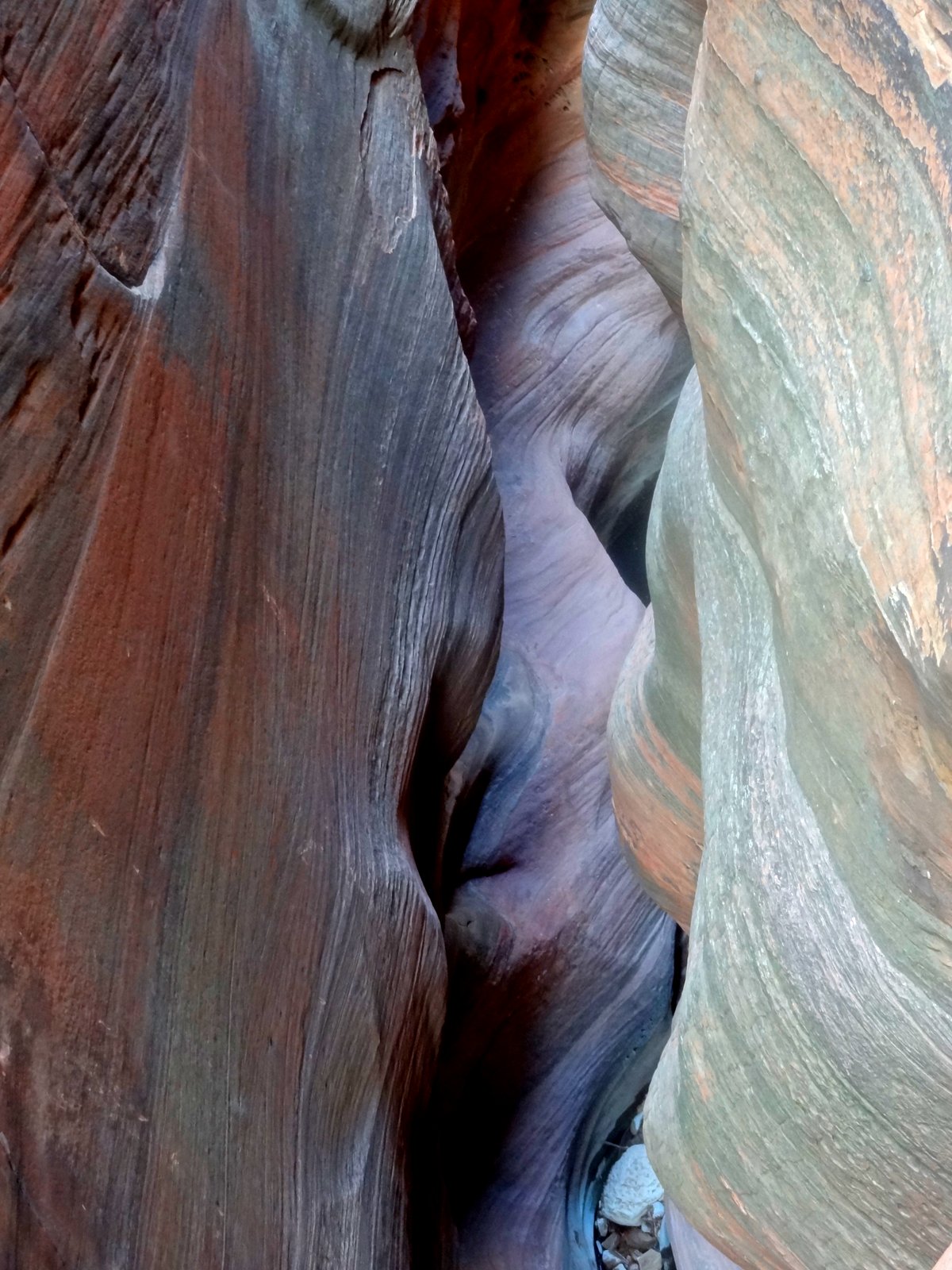
As the trail rounded a corner leaving the view of the canyon behind, it followed beside and above a narrow slot canyon that was probably 50 feet deep and only a few feet wide at the bottom.
Looking down into a slot canyon that we would love to explore someday.
Within a quarter mile, the trail was level with the crevice at the top of the slot and it rounded another corner. Now we were at the bottom of the slot as it continued up the mountain. It was an unexpected surprise - there was nothing to let us know we would be hiking through this.
As it turned out, the trail took us into the upper portion of the slot canyon and it was my favorite part of the hike.
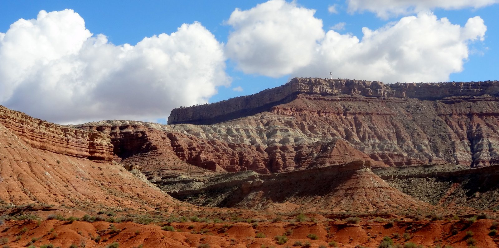
The trail rises to the left and above this canyon for obvious reasons.
We are standing on a sand bed that is probably underwater during times of heavy rain. The trail is at the upper left corner of the picture.
The trail rose quickly. This is looking down into the slot canyon.
After clearing the slot canyon, the trail headed up steeply again. Looking back, we saw this curtain of fog quickly advancing towards us. As you can probably guess - more snow!
We finally were up at the yellow layer that stands out when viewed from below.
As it turned out, hiking while it snowed was wonderful.
The snow never really accumulated and we stayed dry. How perfect!
David stopped to look back and make sure I was still coming.
The end of the trail. It was still spitting snow, but off to David's right, it looked like it could be rain coming.
We didn't linger long. The descent was going to take over two hours and it was already close to 3pm (we started at around 10:30am!)
The snow was gone and we managed to avoid any rain.
Pointleaf Manzanita
The lighting was very different in the slot canyon on the way down.
No more snow and the sun was hitting the tops of the mountains, but the sun was too low to make it into the canyon.
Unlike earlier in the day, the water in the slot was smooth as glass.
Finally, it all makes sense! Dunes! 2,200-foot tall sand dunes over 130 million years ago were compressed and hardened into this sandstone. Now I understand the cross-bedding!
With the end of the trail in sight, I had to have just one last shot of the river rounding Angels Landing at Big Bend.
According to my GPS tracker, this was significantly more than the advertised 8-mile round trip. I recorded a total of just over 10 miles, but it was the elevation climb and the altitude, rather than the distance, that made this one of our most challenging hikes to date. The views made it one of the most rewarding! We will definitely be back to Zion some day.