Wednesday, December 14, 2016


We tried to visit museums in both San Francisco and Sacramento, but we always found our timing was off.  Maybe all California museums are closed on Mondays and Tuesdays.  Joani found a small museum in Chico and since it was Wednesday, we checked it out.

The skeleton below is from a Short Faced Bear that once roamed the North American continent.  Ironic that he should be named "short" anything since he was the largest of all bears.  Today's polar bears are not quite as massive.  Happy enough that I will never meet one of these guys in the woods, but then I have always had nothing but respect for even the smallest bear I have ever met.


The museum was focused on "Fire from the Sky" so there were many displays on asteroids and comets and meteors.  Do you know the difference between a meteoroid, a meteor and a meteorite?


Kate and Mike did a little asteroid mining.

The walking sticks were fascinating.  The museum started with only one, but in isolation it was able to reproduce on its own.  We learned the more mature the insect, the less green it becomes.  The largest guy in the terrarium was close to 10 inches long.


Another extinct North American inhabitant I would rather not meet in the woods.  The Sabre-Toothed cat.  I should have zoomed in on claws - yikes!


Sunday, December 4, 2016, Mt Shasta


We spent a month at Woodson Bridge for several reasons.  We had access in nearby Chico to all the shopping we could want.  After months along the Pacific coast it was a treat to visit a Costco again (love those "store d'oeuvres") and real grocery stores and all those tacky chain restaurants (sausage, egg and cheese Croissan'wiches - our favorite breakfast).

We were able to cat sit while Kate and Mike visited Georgia for a couple of weeks.  Rolling Hills Casino was only a few miles away with a fantastic half-price buffet on Tuesdays and Thursdays (we hit that too many times!).  Our exit, exit 630 on I-5, had a Speedco where I was finally able to get the oil changed in the coach.

Finally, Corning, CA (exit 631) was the olive capital of the world.  It seemed like every direction we drove was through orchards of mature olive trees.  We only managed to visit one olive oil tasting room but we learned quite a bit about harvesting and processing olives.

We had quite a string of rainy or cloudy days, but today's forecast showed promise, so we headed north to spend some time in the shadow of Mt. Shasta.  It was more of a drive than I thought (just over 100 miles), but what a view!  We learned at the visitor center that the clouds that often hover above the peak are called lenticular clouds. Sometimes they can stack in distinct layers and sometimes they stay in place for days at a time.


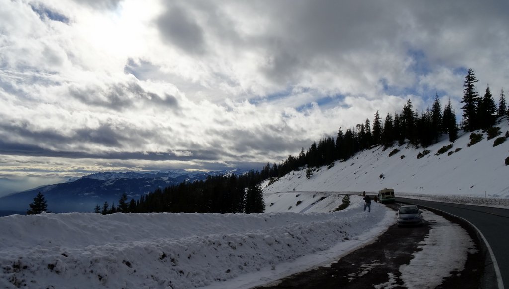
After a quick lunch in the small tourist town of Mt. Shasta we visited City Park where the headwaters of the Sacramento River flow from a large underground spring.  We drove up the mountain - at least as far as it was plowed.  We reached the 8,000-foot level before the road was closed.  There was a large parking area where everyone seemed to be off-loading their snowmobiles.  It looked like it could be a lot of fun as long as you stayed away from the wrong slope.


Consider this a close-up view of Mount Shasta.

Large clumps of snow would fall from the trees and roll down the steep hill building into larger snowballs as they traversed the slope.


The clouds started to thicken giving us some of that cloud drama we like so well.  It didn't even matter that we never saw the peak of Mt. Shasta we had beautiful views in every direction.

The photos that follow are views from Mount Shasta at around 8000 feet up.


We were struck by the near perfect conical form of the trees along the roadside.  You would almost think they were trimmed to their shape.


The view from Lake Siskiyou would have Mt. Shasta above and its reflection on the water if not for the thick cloud cover that blew in during our visit.

Tuesday, November 15, 2016, Move to Corning, CA


Yesterday we drove 97.6 miles (80,247.9 total) and stayed overnight at the Robinson Rancheria Resort and Casino on California highway 20. We went into the casino for dinner and a bit of gambling. The gambling was limited to slot machines and we limited ourselves to the "free play" money they gave us for signing up for a player's card and no, we did not hit the jackpot.


The next morning we enjoyed a leisurely breakfast in the casino before heading out again. Today's drive was 115.3 miles (80,363.2 total) and we settled into sites 28 and 29 right on the banks of the Sacramento River at Woodson Bridge RV Park near Corning, CA.


 Kate and Mike were able to park facing the river so that...

...this was their view at the end of each day!

The kids will be heading back north to Oregon and we will be heading south after our stay here.  I miss them already!!!

Saturday, November 12, 2016, More Avenue of the Giants


We ventured a little further north on the Avenue of the Giants today and explored the area where Mr. Lucas filmed scenes for one of his little movies.  He used these trees as the backdrop to create the forest moon of Endor.  I kept a watch for any low flying speeders, but it was all quiet during our hike.


I loved the shaft of sunlight highlighting this one branch 20 feet in the air.  When I zoomed in closer I discovered there was an eight-legged creature that liked the place enough to call it home.


Another cute family of mushrooms - the "daddy shroom" is less than 2 inches tall.


There is little so majestic as the sun beaming through these giants. We stopped along the roadside to explore for a few minutes. That was when we noticed the sun was warming the trees enough to make them look like they were smoking as the dew was quickly turned to vapor.


The sun's rays had just hit the very wet tree causing it to steam.


The "Immortal Tree" was not really a beautiful tree but given its history, you had to feel a sense of respect.  Lightning, axes, fire and flood, oh my!  I now appreciate how little rain we have had compared to what this place has seen in the past.


 Please note the fish on the tree at the top center of the picture marking the flood level of 1964.

Friday, November 4, 2016, Avenue of the Giants


We took a little drive north along the Avenue of the Giants.  The Avenue is about 31 miles of highway winding through some of the most amazing stands of giant Coast Redwoods.


The short loop hike around the Founder's Grove took us by some interesting sights.  The Founder's Tree below was not the biggest or tallest but it was still quite impressive.  We passed several huge trees lying on the ground that helped us get a different perspective on the 300-foot tall trees.  One tree fell with such a violent impact it splintered into a thousand pieces - it looked like a lumber train derailed and scattered the boards all over.


It amazed me that so much of a giant redwood can be so damaged by fire and yet survive.  This tree has very little remaining at the base and yet it is thriving.

This is the same tree.  I used a flash to see what lurks in the dark inner belly of the burned giant.

Thursday, November 3, 2016, Black Sand Beach


Our camp hosts strongly recommended a trip to the coast.  It meant a slow drive along a winding, pot-holed road crossing the mountains of the King Range National Conservation area (35 miles, 1 hour).  The mountains isolated the area to the point that development has been limited and the coast was mostly forgotten.  Highlights of the Lost Coast included the Black Sands Beach and Shelter Cove.  Although the road was bordering on miserable the views were beautiful.


When we reached the beach, the fog that threatened to close in and keep us from seeing much just made our picture that much more dramatic.  The beach overlook was getting a make-over by volunteers, so we headed straight for the beach. 


The incoming waves were so fascinating.  There was a steep drop-off just offshore so the incoming waves would pile up reaching between 20 and 30 feet before finally collapsing under their own weight.  Signs cautioned visitors of the danger of severe rip tides and let us know we should stay clear of the waves.


The "sand" was buried beneath pebbles making it really uncomfortable for walking in flip-flops.  I was happy to sit and watch the mesmerizing waves.


As the waves crashed on shore they would drive the small pebbles before them making a rattling sound as the rocks bounced and danced. We were sitting maybe 20 feet above the waterline when I realized the waves must have been huge to have thrown the pebbles up to our height.


In Shelter Bay, we were lucky enough to visit the lighthouse when the caretaker was doing a little clean-up.  He was more than happy to give us some history of the lighthouse and the town and the coast in general.  I cannot imagine living along this coast in such isolation, but I was very happy we got to visit.