Wednesday, July 3, 2024, Move to Lunenburg, Nova Scotia, Canada

Our move to Lunenburg from North Sydney was the longest of the tour at 300 miles. Unfortunately, because of the change to the Tattoo schedule in Halifax, the tour route was juggled in a way that we had to retrace the exact mapping we had just driven from Halifax to North Sydney only in reverse with an additional 50 miles tacked on. I would have preferred a different route to see something new but the familiarity made it easy to follow.

Crossing the causeway we left Cape Breton Island behind.

I do mean we followed the exact mapping passing by the same landmarks. The oddly proportioned church below was just before the right turn into the Woodhaven campground. We waved as we went by.


The same schedule juggling meant the Lunenburg campground did not have accommodations for our entire group, so several of us had to set up in the lower section for a night before moving to the upper sites to join the group.

We drove to a Google-recommended "Lunenburg Photo Spot" to view Lunenburg across the water. This town was the most picturesque we visited to date. It is a UNESCO World Heritage site. Established in 1753, it is the best surviving example of a planned British colonial settlement in North America.


After our drive around town, we decided to explore some more on foot. Lunenburg has some very steep hills but overall it was a very walkable place.


Along the waterfront, restaurants, businesses and museums reflected their nautical history. 


The Bluenose II was at the dock and allowed us to roam the deck. The original Bluenose was an award-winning fishing vessel.


The ship's bell was rigged to prevent people like me from ringing it.


I wondered if they might let me take the helm when we sail on Friday.


It was a short day of exploring after a long day of driving but it was clear the town had a lot of potential for being our top spot on the Maritimes Fantasy Tour.

Tuesday, July 2, 2024, Cabot Trail Full Clockwise Trip, Nova Scotia, Canada

The weather was looking good for the day so we decided to tackle the other side of the Cabot Trail. It was almost 90 miles to the western start of the Cape Breton Highlands National Park just north of Cheticamp. At our first stop, the clouds appeared like a giant wave in the surf rolling out across the sea. I don't think the picture below adequately captured the scene. It was beautiful.


This side of the park certainly had its share of hills and curves following the coastline.


Of course, there were beaches full of rocks to explore and not enough time to linger.


From sea level, we climbed some of the steepest pavement we have traveled (I estimated a 15 to 20 percent grade). The view of the water below was fantastic!


At 410 meters above sea level (1350 feet) we explored the French Mountain Bog. The entire loop was on a boardwalk. There was no solid ground anywhere. Signs told us we might see moose - we did not. What we did see was two species of carnivorous plants. The pitcher plant catches insects in water-filled bladders. When they drown they are digested by enzymes in the bladder.

Purple Pitcherplant, Sarracenia purpurea


Another plant, the Sundew lures insects with sticky nectar droplets (the red part of the plant below). Once an insect is stuck the leaf folds around its victim and digests it.


Ferns were a large part of the growth in the bog as well and everywhere we saw whispy, cotton grass.


Cotton Grass, Eriophorum

In one pond we found this Japanese Iris that seemed to be out of place in the bog.


We took a break in our drive to eat lunch. Joani had some hearty seafood chowder while I had a burger and fries. We consulted the map and realized we could retrace our journey to return to the campsite or we could continue clockwise around the Cabot Trail. Each option was just over 100 miles at that point. We chose to continue the loop.


Crossing the island to the east we encountered the steepest hills I have ever driven (even steeper than our earlier uphill climb). The woods were lush and I'm sure provided some outstanding hikes, but sadly, we just did not have the time. Swinging south as we reached the water again at Neil's Harbor we were now on roads familiar from our travels two days ago but this time we had more agreeable weather. Lakies Head was a bit more enjoyable in the warm sunshine than our previous visit.


I believe the picture below, one of my favorite views, is from Pathend Brook Lookout just south of Cape Smokey Provincial Park. Contrast this view with the one from a few days ago when it was overcast and wet.


Taken two days prior on an overcast day.

Many of the roadside signs were labeled in English and Scottish Gaelic. 


We finished the day back at our campground in time for the travel briefing for the following day. After 200-plus miles around the Cabot Trail I could have used a day off but I settled for a margarita and an early bedtime.

Monday, July 1, 2024, Fortress of Louisbourg National Historic Site, Cape Breton, Nova Scotia, Canada

From our campground in Little Bras D'or, NS, it was about a 45-minute drive to the Fortress of Louisburg National Historic Site. A crowd was expected since it was Canada Day (July 1st, 1867, Canada became a self-governing dominion within the British Empire) and park admission was free for everyone. Our National Park passes, provided by Fantasy RV Tours, made it free for us any day but we decided it was best to visit today. On our way, we had to make a quick stop in Sydney to ogle the world's largest fiddle. It stood 17 meters tall (almost 56 feet) and weighed 8 tons. It was created to celebrate the important role music played in the cultural heritage of Cape Breton Island but I think it was just to draw tourists in.

On the water, fishermen were busy even though it was a holiday.

We followed Google Maps only to be turned around and directed back to a visitor center where we had to board a bus to the site. It wasn't a complete waste of time - we caught a different angle on the fort and more fishermen in the fog.

After we exited the bus we explored an old fisherman's sod roof home where volunteers were dressed in period garb. A fellow gave us a glimpse into life in the 1800's. He explained how Cod were caught, processed, and shipped to France. It turns out you can salt and dry Cod (apparently only Cod) to preserve them indefinitely. Just rehydrate and rinse the salt away and the fish is just like fresh. I guess without refrigeration you had to be creative.

A short walk away, we reached the guard house where they actually had a drawbridge over a moat. The moat was open to the sea so I doubt it was very effective for repelling attacks.


Just beyond the drawbridge were guard barracks and then the armory and more barracks.


The governor lived in the big house high on the hill. It also contained the church and barracks for another 700 officers and soldiers.


Oddly, there was a separate guard house outside the building full of soldiers. Half of the building below was for the captain of the guard and the other half housed another dozen soldiers.


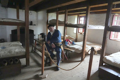
Another character filled us in on life in the barracks. Each bed was assigned to three soldiers. Each had a straw-filled mattress for 8 hours of the day. They cooked in the room, washed in the room, and slept in the room. Work details ran 24 hours a day and the soldiers were basically a labor force to build and main the fortress.


The number two man lived in the house below. It was probably well appointed and comfortable in its day but now it housed Legos, lots of Legos.


Only one room was inside the house now and it was covered by a Lego model of the entire fortress. It was fascinating to study the details someone had worked into the model. They had a sense of humor as well judging by the gulls and lobsters spread throughout.


When we left the Legos we walked into a fog bank that transformed the landscape. It lifted almost as quickly as it had rolled in.


In the garden area behind the captain's house, Joani found wild Columbine flowers that were colorful but less full and varied than today's blooms. The captain, by the way, was quite the devious one. He also ran a pub and kept the soldiers in debt so they would have to re-enlist to pay their tab.


As part of the program, a cannon was fired at the close of the fort each day. A detail of soldiers marched through the streets to the sea wall to perform the ritual. Drummers drummed and fifers fifed as the crowd built behind them. 


We followed for a bit and snapped our pictures. Joani found this little guy to be precious as he directed his parents to follow the soldiers.


The crowd grew larger as we approached the fortress wall. We realized they were all going to head for the bus as soon as the cannon was fired. We decided to get ahead of the crowd to the buses instead of waiting for the big "BOOM". We reached the bus and boarded with no wait. Almost immediately after the bus started rolling it started to sprinkle. By the time we reached our car, the rain fell in earnest.