Showing posts with label Montana. Show all posts

Wednesday, July 9, 2014


While we were still in Great Falls, I called the Cummins shop in Billings and set up an appointment for some service.  The way appointments were scheduled, we couldn't get there early enough on Wednesday, so it would have to wait until Thursday.  That meant we could take our time, so we took to the back roads again.  The Montana roads were very nice and it was a pleasant drive.


As we approached Billings, something hit me when Joani said "turn right on Zimmerman".  That was the steep, winding little road we had taken before to get to the top of Rim Rocks overlooking Billings.  I went straight and we pulled over to recalculate our route which then took us through the heart of downtown.  It got a bit tight, but we made it to the service center (227.0 miles trip, 69,401.6 total) with just a little bit of white-knuckling.  We checked in at the service desk, unhooked the car and parked for the night.  

I met a nice couple from Georgia, Elwyn and Judy, who were in for repairs.  They had a fuel line problem that was taking longer than expected to diagnose and fix, but they were still intent on making it all the way to Alaska.  Their card had a picture of a beautifully restored 1957 Ford Fairlane Retractable Top.  My first car, also a 1957 Ford Fairlane, never looked so good even when it was new.  He said it took him four years of work spread over a five year period to get it into its current condition.  That's a commitment I'm sure I will never make.

Sunday, July 6, 2014


We were as close to Glacier National Park's "Going to the Sun Road" as we were going to get, so that was our goal for the day.  It meant a lot of driving, but it also gave us the opportunity to preview how the border crossing at Chief Mountain would go. 

No line at the border, that was a bonus.

Back into Montana we saw signs warning us to watch for open range cattle - our Honda FIT has great brakes so the cattle were no problem, but in the coach I will have to drive a lot slower and stay vigilant!

We now had a heads up that we will be sharing the road with our bovine friends.

Chief Mountain viewed from the Montana side looks a lot like the view from our RV site in Canada.  Its very distinctive shape is what makes it such an icon among all of the other mountain peaks in the area.  Like so many of the unique places in the west, this one is still a sacred Indian site and has been for many hundreds or even thousands of years.

Chief Mountain is shared - located on Glaciers eastern border and the Blackfoot Indian Reservation.

It is 50 miles from West Glacier to St. Mary at the east entrance.


From the east entrance to Glacier, the Going to the Sun Road was pretty rough gravel undergoing repair for about 10 miles.  I thought, if the entire road is no better than this, we may not make it to the top. Fortunately, we cleared the construction zone and the road was remarkable well maintained.


Logan pass still had a lot of snow piled up.  It was warm and it seemed like the snow was melting, but I suspect they rarely ever see all of the ground around this Visitor's Center (elevation, 6880 ft.).

This was a challenging year for the snowplows.  The road didn't open until July 3, 2014.


The Weeping Wall was fun to drive by in the car.

I would think for motorcycles and convertibles, not so much.

We traveled the road over the pass and saw most of the features highlighted on the map.  Once we passed the Loop we turned around and headed back.  It was only a few more miles to Avalanche Creek (the eastern most point of our travels from the west entrance a month ago), but we thought we had seen most everything of interest and it was already getting late in the afternoon.  Next time maybe we will drive the entire length and back in one day.


The Triple Arch was easy to miss heading west, but could easily be seen while driving east.

There was a little of the glacier blue showing through the holes in the snow.

One of the best views along the road was near the east end of St. Mary Lake where Wild Goose Island was framed by the trees with the mountains in the background.  It was "closed" but I flagrantly ignored the orange cones that tried to deny us access to this iconic picture. Once I pulled in between the cones it seemed to start a little trend as others did the same. 

Wild Goose Island is an iconic view of Glacier.

We stopped at the East Entrance Visitor's Center on our way out.  I saw in the corner a new Celestron, 14 inch, Edge Optics Telescope on a CGEM mount.  The Ranger said there was an astronomy session that night starting at 9:30 pm.  Sadly, the border was closed at 10:00 so there was no way to stay.  I found out a bit later, from the Ranger who does the astronomy program, that the telescope was in fact, just out of the box and had not been under the stars yet.  It also was not going to be used for a while because the "boss" wanted to be there when it was used for the first time.  I did get a good peak at the sun through a couple of telescopes set up for solar viewing.  One was "white light" showing quite a few sunspots and the other was a hydrogen-alpha scope that showed spicules and prominances. 

A Ranger suggested we should not miss a drive along the Many Glacier Road to the north.  It was said that it is, to some, the heart of the park.  We were underwhelmed after just having seen the fantastic views along the Going to the Sun Road and I'm not sure we even took a single picture.  We did stop in for some frozen yogurt and a few cold drinks that hit the spot.

Back at the border we found ourselves in quite a long line including maybe a dozen or so folks on motorcycles.  Hopefully when we pass through in the coach it will be more like the morning crossing (no line) than this!


It was another one of those long days where we almost could not remember all of what we had seen and done and it felt so good to be back at the coach where we could relax.  We need to remember we are retired - we are not on vacation - we have to pace ourselves!

Saturday, July 5, 2014


Today we opted for the much heralded Waterton Inter-nation Shoreline Cruise.  The 10:00 departure would allow us to do a little hiking on the U.S. side from the Goat Haunt Port of Entry.  That required us to get moving a little earlier than normal, but every now and then you just have to make some sacrifices.  On the way into town, we had to pull over for the Big Horn Sheep parade.

It was early, 9 am, and we were heading into town to take the Waterton Lake Cruise.

My camera was stowed in the backpack and David's was tucked away in the backseat.

If you could have seen me frantically trying to retrieve David's camera, you would have laughed.

David managed to capture the magnificent beasts (bad hair day, notwithstanding.)

We got our tickets early which allowed us to explore the Waterton township a bit.  Joani deemed a lot of the houses "adorable".  We found Cameron Falls just a few blocks away from the lake.  It was quite an unexpected surprise - there was a lot of water coming over the falls making for some nice shots.


The cruise was only about half booked, so there was a lot of room.  We sat on the top in the wind and I wished I had brought a jacket.  I believe we were told the water in the lake never gets above about 60 degrees.  I suspect it was a lot colder than that and coupled with the 50 mile per hour wind - it was cold!

The International was built the same year as the Prince of Wales Hotel, 1927.


The lake and scenery were beautiful.  We crossed the border with little fanfare.  It was clearly marked with a clear-cut line along the 49th parallel (apparently, a treaty requires the clear delineation of the border). 


The little structure in the center of the picture down by the tree line is where, in 1927, they built the boat we were cruising in.  It is also where it is stored for the winter.


A parting shot of our boat.  Let's just hope it comes back for us!

As we were presenting our passports for entry into the U.S., it was difficult not to think about the absurdity of the process given just exactly where we were.  It's not like we could of continued on into the country from here - the only way out was by the same boat that brought us here.


Kootenai Lakes were supposed to be one of the best moose habitats in the park.  We were looking forward to seeing many moose.  The CBE (Customs & Border Enforcement) officers said there was a grizzly sighting earlier, so we should we be cautious.  The trail was 4 km (about 2.5 miles) one way with very little elevation change, so it was an easy hike.  What caused us a little concern was the requirement for us to be back in less than three hours.  We're not usually in much of a hurry.

Bear Grass is such a whimsical plant it brings Dr. Seuss to my mind.

Bear Grass is not really a grass.  It is in the Lily family.

We made it to Kootenai Lake, but where are the moose?

12:30 is not a good time for wildlife viewing.  All intelligent creatures are napping.

A parting view of the lake.  Our time was limited.  If we were not back on the dock at 2:30, the boat would leave without us.  

The rocks in the creek bed look so vibrant when wet, but when dry on the path, not so much.

We made it back by 2:00.  Hiking under a time constraint puts a pep in your step!

Crossing the international border on our way back into Canada.

The captain paused the boat to point out this wrinkle in the cliff.  It takes powerful forces to cause a fold like this!

This hotel looks much better from afar. Built in 1927, it was named after Prince Edward, who later became King Edward VIII.


It stays light so late that we decided to take a little road trip to Red Rock Canyon.  What amazing luck to see a mother Grizzly and her two cubs ambling along the roadside as we entered the park.  They were about 40 feet off of the roadway and oblivious to the traffic jam they caused.

A Grizzly and her cubs meandering to the side of the road - We did not get out of the car!

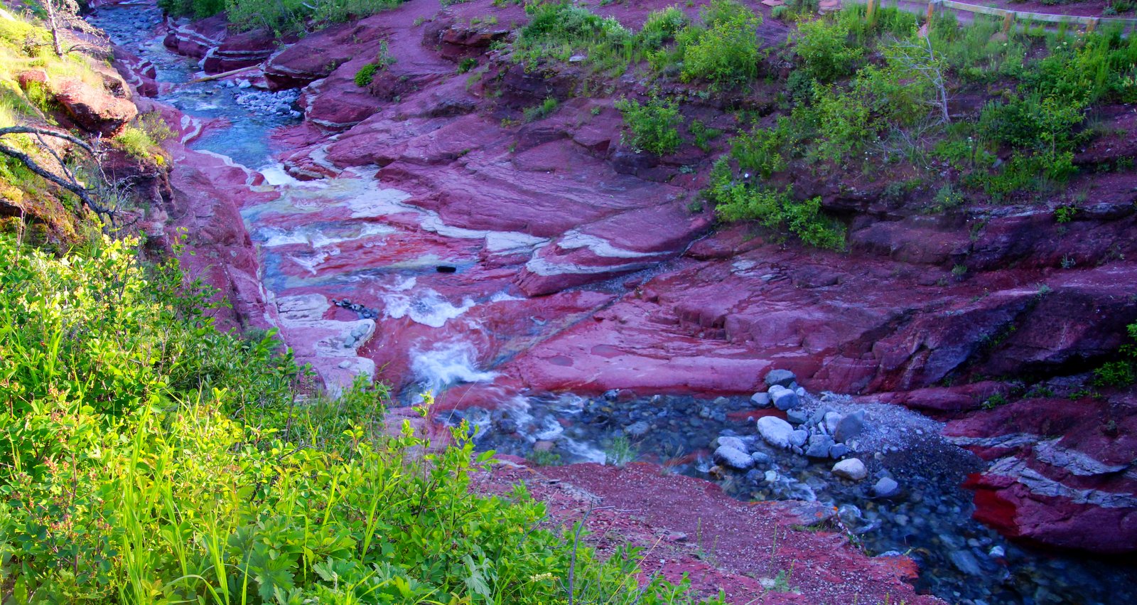
What else could they call this but Red Rock Canyon?  The name slighted the purple cast to the rock, but I shouldn't over think this.

"Magenta Rock Canyon" doesn't have the same ring as "Red Rock Canyon".  The color was amazing, but the lighting was not.

Too late in the afternoon for the sun to reach down in the canyon.  

Heading back to the car, I was passed by a man running with his camera - he said "there's a big black bear over there".  He was running towards it, so I thought I might take a look too.  It was the biggest black bear I have ever seen and there were two cubs along with her.

This black bear was foraging alongside the parking lot.  I hurried Sam into the car.

They were foraging through the woods ripping apart rotting trees looking for grubs.  The downed trees practically exploded into kindling as she effortlessly swiped at them.  

We watched the mom and two cubs from the safety of the car.


We got into the car and slowly cruised by her.  Sam saw her and barked as I rolled down the window.  I wasn't sure if she was noticing the noise or our scent - either way, I was ready to move out quickly if she got too close to the car!

I took video of her trying to tear apart a rotting log.  Ants, termites, beetles, and bees' larva contain 80% - 90% protein (beef - about 20%)


As we headed home on Red Rock Parkway, we caught the peaks highlighted by the setting sun and saw yet another Grizzly.  This one was almost too far away - even at full zoom there was not a lot of detail. I have to admit, we were extremely fortunate to have so many sightings in such a short span of time - it was kind of exhilarating!


It was a long day, but a memorable one!